

")


 Whats app
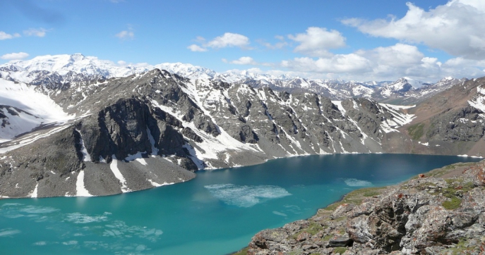
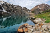
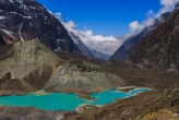
Ala Köl, also Ala-Kul, (Kyrgyz: Алакөл) is a rock-dammed lake in the Terskey Alatau mountain range in the Ak-Suu District of Issyk-Kul Region of Kyrgyzstan. It means "motley lake" in Kyrgyz language. Located in the upper reaches of the river Kurgaktor (right inflow of Karakol) at an altitude of 3532 meters. It has a glacial origin: the glacier after the retreat still occupies the upper part of the valley.
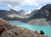
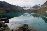
Lake Alakul (Alakol) lies in the glacial valley of the left source of river Kurgaktor (right inflow of Karakol) at an altitude of 3532 meters above sea level. The length of the lake 2.8 km, width 0.5 km. The coastline is 6.8 km. This is perhaps one of the most beautiful places in the Terskey-Alatau area. You can’t get to the lake by car. You can get there on foot or on horse. Diving is not possible, because of poor visibility and difficult accessibility..
The road to the lake from Karakol valley begins just below Ayutor river (the left tributary of the Karakol river). You can pass the stream by a footbridge (made of several logs with an iron rope as a handrail).There is a 3 km road here from a merger of Koltor and Ontor. There is a fenced area on the right bank of Ayutor. According to some sources there was alpine camp located here (according to other sources alpine camp stood on the merger). Ayutor river is really small so road just crosses it, but if you do not want to go through it, then two hundred meters further there is a bridge.
The path leading to the lake, immediately enters the forest. It rises quite gently and gradually goes to the left, leading out to the rather large meadow, which ends by the steep grassy slope of an old landslip blocking the valley. Next, serpentine trail climbs the slope then goes right and over the rocks and then leads out to the river flood. (Below the landslip the water goes under the stones and will not appear until Karakol). A little further upstream is a small log cabin, the so-called shelter "Sirota". Beside him, on chipping there is a good place for tents among the trees. Way here from the river takes about an hour and a half.
Above shelter forest ends and the trail goes along the coast. Soon the valley splits apart : straight path goes to the Kurgaktor pass(1B), and to the right, along the stream there is a main trail leading to the lake.
The water here is quite steep falls in cascades over the rocks, so it is necessary to climb along the rocks. Above, to the left after the turn, the river flows through the bottom of the gorge, leaving enough space for the trail, but then gorge narrows, becoming steeper, and you have climb to the left on the rocks.
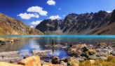
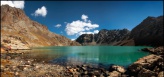
Then again, the valley widens and the trail takes a steep left once retreating glacier moraine forehead above which the ravine closes smoothed rock walls. With these breaks rocks beautiful waterfall flowing directly from the lake. From here the trail goes left into the scree, and then gradually rises to the right, bringing up rock dumps on the flat monoliths serving as a dam. With them directly overlooking the lower part of the lake. If desired, on the stone slabs can put up a tent. Climbing from the shelter to the lake takes about 2 hours.
The lake is big: from west to east it stretched for 2.8 kilometers, and its width - about 500 meters.
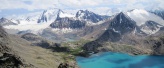
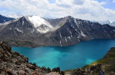
Directly to the south of the source of the river you can see saddle of the Panoramic pass (1A), leading to Koltor river. To see the upper part of the lake, it is necessary to go to the left along the path that gradually climbs to the top of the rocky crest. Then she goes traverse the slope, avoiding the bottom several ridges that occur on the way, and then gradually chosen to pass Alakul. With trails offer excellent views of the lake, as well as the rise in the south is visible and the main Terskey-Alatau peaks Aksu, horseman, Karakol and Oguz-Bashi. The best time for photography from the pass - either morning or evening. In the middle of the day the sun shines directly into the eyes. So if you come to the lake in the afternoon, it is better to walk down the trail to the beach and stay for the night.
Photo

on map